Truck & Fleet GPS Navigation for Professional Drivers
Optimize road transport with Fleet Navigation GPS system.
GPS for truck routing streamlines logistics
& reduces costs. Try it today!

Supporting 3,000+ fleets and 4+ Million professional drivers


Commercial navigation packed with functionality
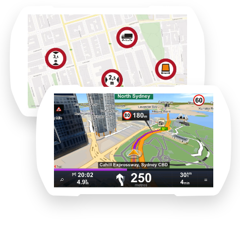
Commercial Routing
You can set parameters like vehicle length, height, width, and more, to avoid all roads unsuitable for trucks, special cargoes, or hazardous materials.
Full Offline Functionality
Navigate even in areas with limited or no data coverage thanks to maps stored on a phone/tablet.
Premium Quality Maps
Use the latest maps from our providers (HERE, TomTom, OSM, etc.) that virtually cover the whole world.
Execute Routes as Planned
Import routes so drivers can follow the route exactly as planned by a 3rd party planning or optimization tool, avoiding any undesired driving deviations.
Support for All Platforms
Supports all major operating systems (Android, Windows, Linux, iOS) as well as a wide range of hardware.
Accurate ETA
Our ETA is specifically tailored to professional drivers. The calculation is based on historical speed profiles, thereby making ETA predictions highly accurate.
40+ Languages
The user interface and voice guidance are available in more than 40 languages.
Prefer Right Turns
Avoid time-consuming and dangerous left turns at intersections against incoming traffic.
Destination on the Right Side
The navigation can calculate the route to allow the driver to reach the destination on the right side of the road.
Real-time Traffic
Avoid delays on the route, save fuel and have exact ETAs for time-critical assignments.
Speed Cameras
If the driver exceeds the speed limit while approaching a fixed speed camera, Sygic Professional Navigation alerts the driver in advance and indicates the speed limit.
Geo-Fencing
Allows areas on a map (geofence polygons) to be highlighted and to track vehicles and assets in this area.
Offroad and Municipal Routing
Navigate on routes that don’t match the official road network (unmapped roads, industrial areas, or off-road segments).
Emergency Routing
Navigation allows vehicles with special permissions to enter pedestrian zones, make forbidden maneuvers or go against the direction of traffic to get to the incident faster.
Most Popular Use Cases

LGV & HGV trucks, special cargo, Hazmat... set the parameters and we will guide you the right way.

Door-to-door delivery with multiple stops, route import, accurate ETA with time-domains, and more.

Special routing and offline functionality
for a faster response and reliable service from first responders

Plan, execute and monitor field work and services with itineraries & custom map overlays.

Navigate back and forth on a single street, on unmapped roads, in industrial areas, or off-road.

Make use of maps containing taxi lanes and millions of POIs such as hotels and restaurants

Avoid roads restricted for hazardous materials and navigate using your own maps.


What our clients say about us
Start a conversation today
Get in touch with our team of experts by filling out the form.
You will get personalized advice and guidance.

Start in our Support Center.